PROJECT
Barloweerie Project
TARGET COMMODITY
Zinc, lead, silver, copper and gold
LOCATION
Murchison District of Western Australia, 525km north of Perth and 150km west of Cue.
TENEMENTS
506.2km2 of exploration tenements either granted or under application.
SUMMARY
The Barloweerie Project covers part of the Barloweerie Greenstone Belt which consists of a sequence of mafic and felsic volcanic rocks, minor ultramafic, banded iron formation (BIF) and metasediments forming what is termed the Barloweerie Formation. The felsic volcanics, metasediments and BIF/chert form the core of a tightly folded north plunging syncline. The Barloweerie Greenstone Belt is bounded by a metagranite which may show foliation indicative of regional deformation.
Regional magnetic data indicates the presence of a series of northeast trending Proterozoic dolerite dykes, particularly in the northern section of the project area. These were also noted in historical prospect mapping where outcrop exists. Base metal mineralisation has been identified in host rocks which display intense silicification and chlorite ±sericite alteration.
Locally, mineralisation containing up to an estimated 15% sulphides has been reported. Sphalerite and galena are listed as the main minerals with pyrite, pyrrhotite and chalcopyrite also present. Metamorphic grade is generally amphibolite facies particularly in the granite margins where contact metamorphism occurs.
Outcrop in the southern area is very limited, with bedrock being obscured by superficial deposits. Interpretive mapping by the GSWA indicates the southern part of the project area is underlain by foliated metagranitic rock with interleaved minor metamorphosed mafic, ultramafic, and local sedimentary rocks. The presence of a greenstone sequence undercover in this area is also supported by aeromagnetics.
The Barloweerie Project has had limited modern exploration since 1987 (refer Open file WAMEX open file report a021129) when strong mineralisation was encountered in RC and diamond drillholes, including:
- 5m @ 4.8% Zn from 38m (SDH34)
- 1m @ 3.9% Pb from 15m (SDH19)
- 5m @ 100.0g/t Ag from 28m (SDH31)
- 2m @ 0.58% Cu from 19m (SDP8)
The Barloweerie Project has multiple Zn-Pb-Ag-Cu-Au drill targets.
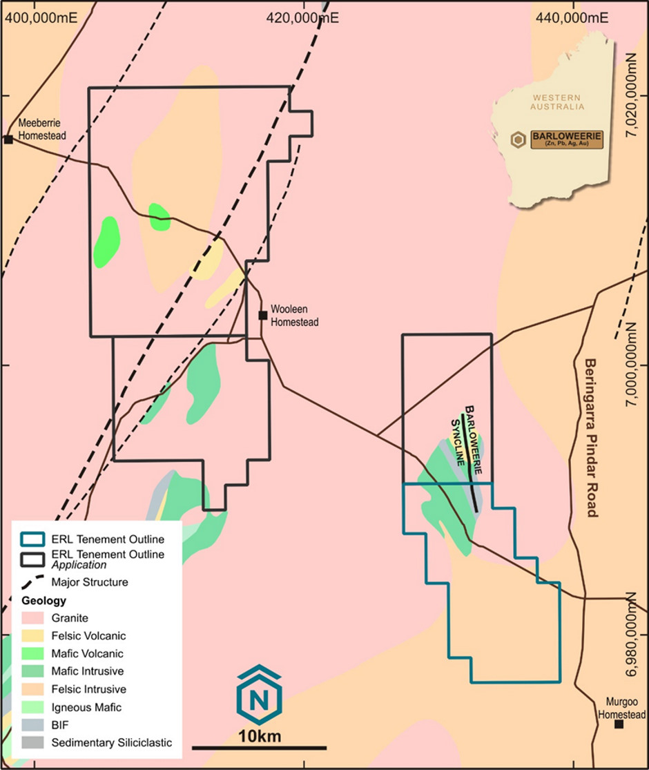
Figure 1 – Barloweerie Project Tenements.
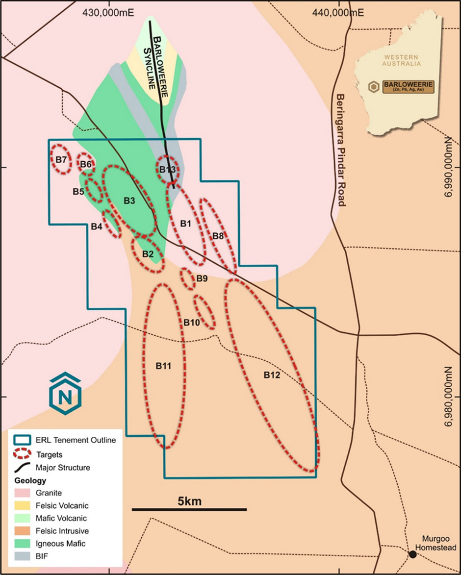
Figure 2 – Barloweerie South-East Project Area and Prospects.
B1 PROSPECT – HISTORICAL HIGH-GRADE MINERALISATION
The B1 Prospect is characterised by outcropping mineralisation over a strike length of 2km based on historical drilling, surface geochemical sampling (LAG and rock chip) and mapping. Historical drilling has been focused along a gossan where a steeply dipping siliceous zone containing Ag-Pb-Zn-Cu mineralisation over a strike length of 100m and a width of 10m has been identified.
Due to the limited historical drilling known mineralisation is considered open in all directions. Based on established metal zonation there is potential for copper mineralisation to increase with depth, particularly if a feeder pipe is discovered. Potential also exists for the discovery of Au-Ag vein mineralisation based on geochemical assays and the proximity of the B1 prospect to a granitic intrusion immediately to the east.
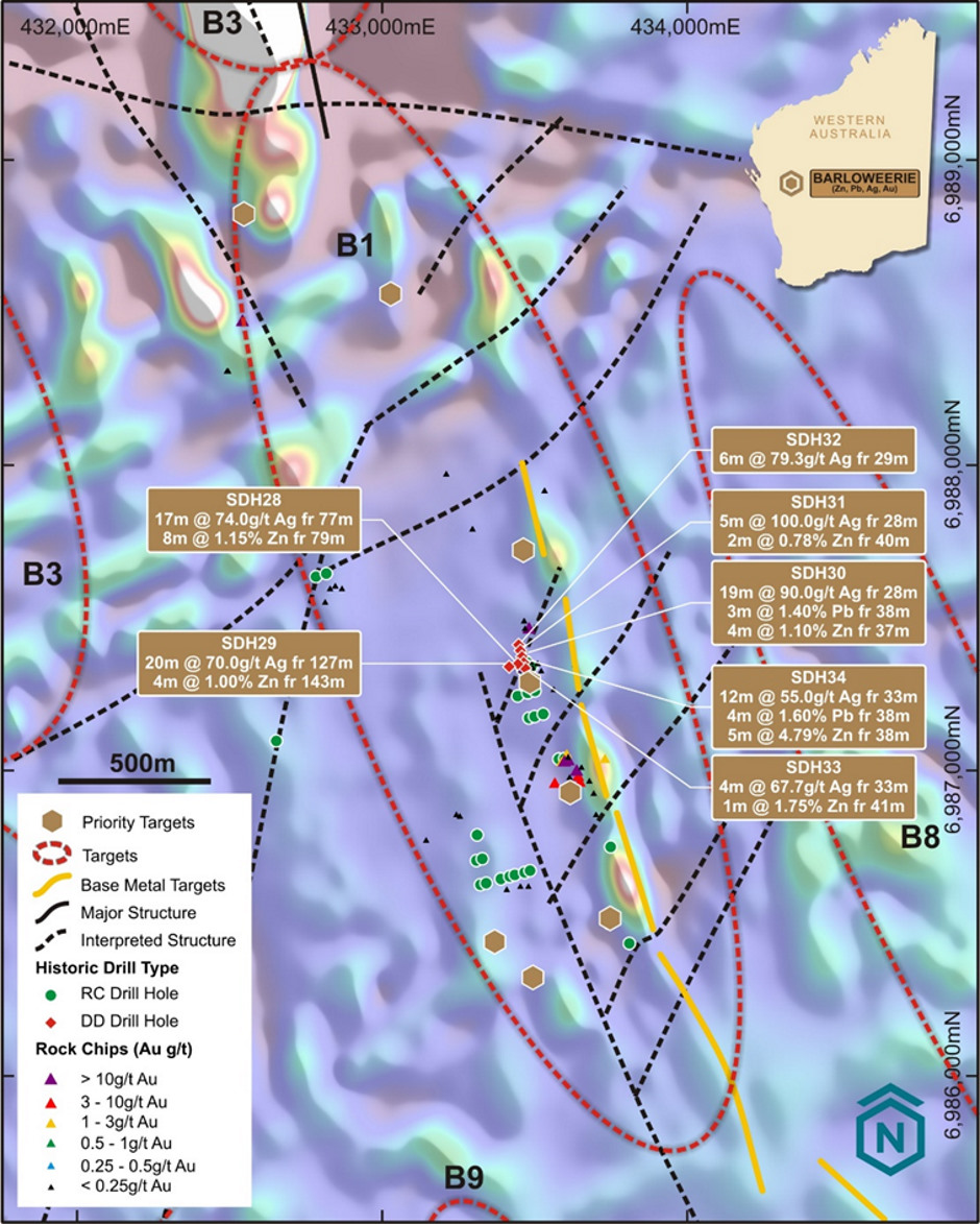
Figure 3 – B1 Prospect Historical Drilling & Interpreted Structures.
COMPETENT PERSON STATEMENT
The information in this report that relates to Exploration Results is based on information compiled and/or reviewed by Gerald Johnson, who is a Member of the Australasian Institute of Mining and Metallurgy. Mr Johnson is an independent geological consultant and has sufficient experience that is relevant to the style of mineralisation and type of deposit under consideration and to the activity he is undertaking to qualify as a Competent Person as defined in the 2012 Edition of the “Australasian Code for Reporting of Exploration Results, Mineral Resources and Ore Reserves”. Mr Johnson consents to the inclusion in the report of the matters based on this information in the form and context in which they appear.